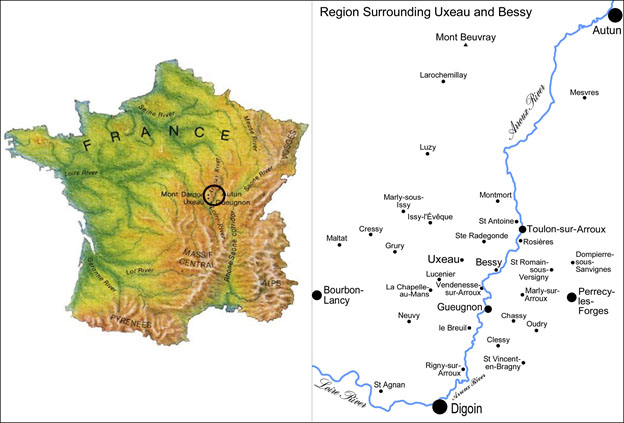
In many ways the landscape in and around the Commune of Uxeau in southern Burgundy (Figure 1) appears similar to the countryside depicted in late medieval illuminated manuscripts. The hilly landscape is a patchwork of small plots of pastures, meadows, fodder and grain crops all bordered by hedgerows, and dotted by centuries old farmsteads and small villages. While this landscape has remained one of family farms since at least the middle ages, its seemingly static appearance belies a dynamic history of creative adaptation to changing climate, economic and sociopolitical contexts. This continuity and change has been the focus of our ongoing, long-term research project. Major changes have occurred in the last two centuries with the shift from a subsistence grain economy to a pastoral market economy based primarily on cattle. While the present range of crops and animals is still diversified in the area, some things like hemp and vines have disappeared from the repertoire. In order to understand the complex history that has produced the present landscape we utilize the theoretical framework of Historical Ecology, an interdisciplinary focus on the interrelationship between humans and their environment. The data and types of analyses we bring to bear in studying the landscape include 1) a series of maps ranging in date from 1759 to 2012 and integrated within a GIS database, 2) historical records such as cadastral tax records, agricultural reports, and population data from censuses and parish/civil registers, 3) environmental data from ponds (pollen, sediment geochemistry, grain size, stable isotopes and 4) oral history/ethnographic interviews with local rural inhabitants.

Fieldwork
A predominant feature of this landscape is water and that was the focus of our April 2013 field survey. The area is interlaced with streams that have been dammed to form ponds, many dating to the middle ages. The creation and maintenance of these ponds with their earthen dams required a great deal of labor and expense. Our research has shown that these man-made ponds were used to water livestock, raise fish for domestic consumption and sale, launder clothing, soak hemp for processing, and for recreation. One of the most important functions of ponds in the past was to run mills, primarily for grinding grain, but also for pressing oil and cutting lumber. Many of these mills have disappeared and many of the surviving mill buildings are endangered due to neglect or redevelopment. Our survey in April 2013 of ponds and mill sites identified from the historical maps was designed to 1) document the remaining pond and mill sites, 2) verify our historical data, 3) test new technologies, and 4) to better understand the conditions and changing function of these features in the present economy.
The field survey included 1) assessing, videoing and photographing the sites, 2) verifying their location by taking GPS points and through the use of the Garmin GPS to align historical maps with the present landscape, and 3) interviews with some of the present owners of pond and mill sites. Our survey in April combined with our surveys from 2008 and 2009 documented 52 ponds and 27 mills. In 2009 we interviewed 5 pond owners, and in 2013 we interviewed and filmed statements of 3 mill owners.
We visited the Archives National in Paris and the Burgundian Departmental archives at Mâcon and examined 85 folios of documents relating to water and land use. These documents included 5 new maps of the research area dating to 1790, 1843, 1888 (2 maps) and 1900. These will be georeferenced and features will be extracted and entered into our project GIS. We recorded notes of key information and took over 4,000 total photographs, approximately 2,000 of these of archival documents and maps.
GIS, GPS and related technologies
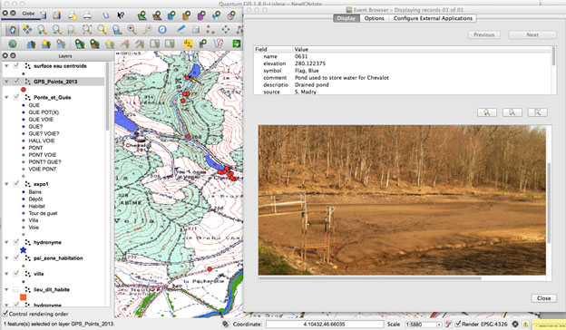
Our project ‘s long term focus on the interaction between people and their environment has used Geographic Information Systems (GIS) technology for many years, including the use of public domain and open source tools. For this work, we explored the use of the new Event Visualization Tool (eVis) in the public domain QGIS software to document the various mills and dams in the area. The eVis tool (http://biodiversityinformatics.amnh.org/open_source/evis/) is a plugin that allows us to embed geocoded photographs, images and other digital documents directly in our GIS environment (Figure 2). This new ability to ‘see’ the location from the ground adds tremendously to our ability to represent the landscape in GIS and also to connect the digital data with a view that can be easily understood by non-specialists.

Another successful aspect of our fieldwork involved viewing several of our historical maps in our handheld Garmin GPS. The new Garmin eTrex receivers allow you to view a georeferenced custom map as the backdrop of the screen. This is the first time, to our knowledge, that this approach has been used for such archaeological surveys. We put several of our historical maps onto the GPS SIM chip and then were able to navigate on foot or in our car, and see exactly where we were on the old maps, and were able to identify several remnants of old mill structures, roads, and other features in this way.
Research Results and Conclusions
Our research has shown that in the last few decades, the number of family farms in the study area is dwindling. Abandoned farmhouses are being bought to function as summer vacation homes for urban dwellers from cities like Paris and from the Netherlands, or for year-round retirement homes. Farmers are adapting to this emerging recreational landscape by renting out rooms and cottages to tourists. The fate of the mills we studied is similarly affected by this shift in the economy. Some mills like the ones we documented at Chevalot-du-Bas and Chevannes have been abandoned and are simply falling into ruin (see Figure 3). Others like the mill at Megniaud are empty and put up for sale. Some mill buildings have been converted into vacation or year-round retirement homes like the mill at Barnaud. Other mills have been turned into the homes of farmers like the mill at Bauzot, where the farmer has also turned the area of the former mill pond into a commercial fishery producing fingerlings for stocking rivers and ponds. Some people hope to restore their mills as an important piece of local historical heritage, like the mill at les Taupières where the associated manor has been turned into an inn and restaurant.

Our research will continue to explore the long-term history of the inhabitants’ relationship with this landscape and we will expand our work beyond mills and ponds to include woods, pastures and meadows, croplands and former vineyards. For further information on our project and work, please see: http://burgundylandscapes.com.
Selected Publications Available Online:
Jones, Elizabeth A. 2009 Multi-temporal Landscape History in Burgundy: An Innovative Application of Genealogy Software. Annual Proceedings of Computer Applications in Archaeology.
Madry, Scott, Elizabeth Jones, and Amanda Tickner. 2009 An Improved Method for Extraction of Historical Cartographic Features into GIS: A French Case Study. Annual Proceedings of Computer Applications in Archaeology.