The first season at el-Kabri was conducted between June 29 and July 12, 2014, for two weeks. The season comprised two components: a surface collection survey by walking transects and a simultaneous total station survey. The survey was conducted under Permit Number S-477/2014 issued by the Israel Antiquities Authority. The surface collection survey was supervised by Katie Blanton (UNCG, BA 2013) and joined by Kyle Brunner (UNCG, BA 2014) and Courtney Miller (UNCA, BA 2014). The total station survey was conducted by Elise Thing (Copenhagen, MA student) and Bruno Cardoso (Copenhagen, MA student). The project was funded by a Dumbarton Oaks Project Grant and a UNCG Proposal Preparation Grant.

The site of el-Kabri, in the western Galilee, occupies the area north and south of the east–west Nahariya-Ma’alot Road (Number 70). It is mainly on property owned by Kibbutz Kabri, which is on a hill overlooking the site. The site is on the southern slopes in the coastal plain (an alluvial valley, around 2–5 km wide) at the farthest eastern point where the elevation begins to rise just east into the foothills of the Galilee. The main water source is the Nahal Ga’aton, a perennial stream watered by two springs: ‘Einot Ga’aton and ‘Einot Kabri. This was the water source for ‘Akko and traces of aqueducts and flour and sugar mills between Kabri and ‘Akko attest to its use in antiquity year round.
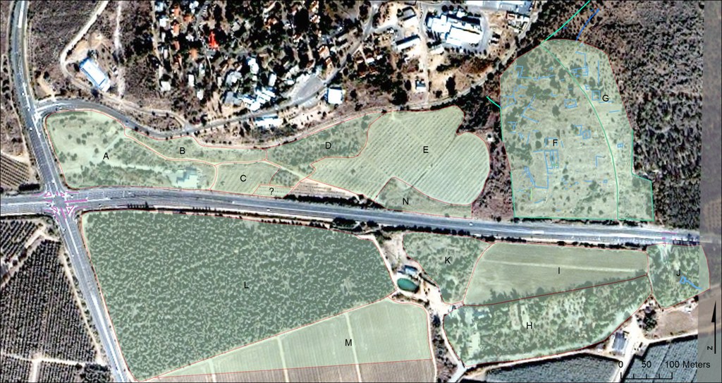
The surface collection survey was conducted on either side of the Nahariya-Ma’alot road on agricultural and pasture land. The survey area was divided into fourteen smaller areas based on field boundaries. Field walkers were spaced 5 or 10 m apart depending on terrain type and density of artifact scatter on the ground. Artifact density maps will be produced for the total number of artifacts and sherds by period to determine concentrations for future excavations. These will be overlaid with the topographic map produced by the total station survey to guide placement of excavations further and to determine limits to the site itself. Area F, the area farthest east, was the densest part of the site in remains and artifacts. The field is a horse pasture and populated with scrub, thorns, cactus, and visible bedrock. It had good-to-excellent visibility and visible architectural remains and artifacts, indicating two separate sites. To the north and east was the Ottoman/Palestinian village of el-Kabri, bulldozed in 1948 but known from Ottoman tax registers. To the south and west were mainly concentrations of late Roman/Byzantine ceramics (fourth–seventh century) and architecture that may be tentatively dated in association of the Byzantine or early medieval/early Islamic site. Parts of this site were revealed in salvage excavations on the south side of the road that uncovered wine and olive presses, monumental buildings, and a possible church (Smithline 2004; Abu-‘Uqsa 2007; Zingboym 2008). Among the standing remains (ten separate walls), we identified an east–west-oriented building with a patch of decorated black and white mosaic floor that strongly resembles a church or other monumental building in two phases. The building was constructed on a mound on the highest part of the lower site.
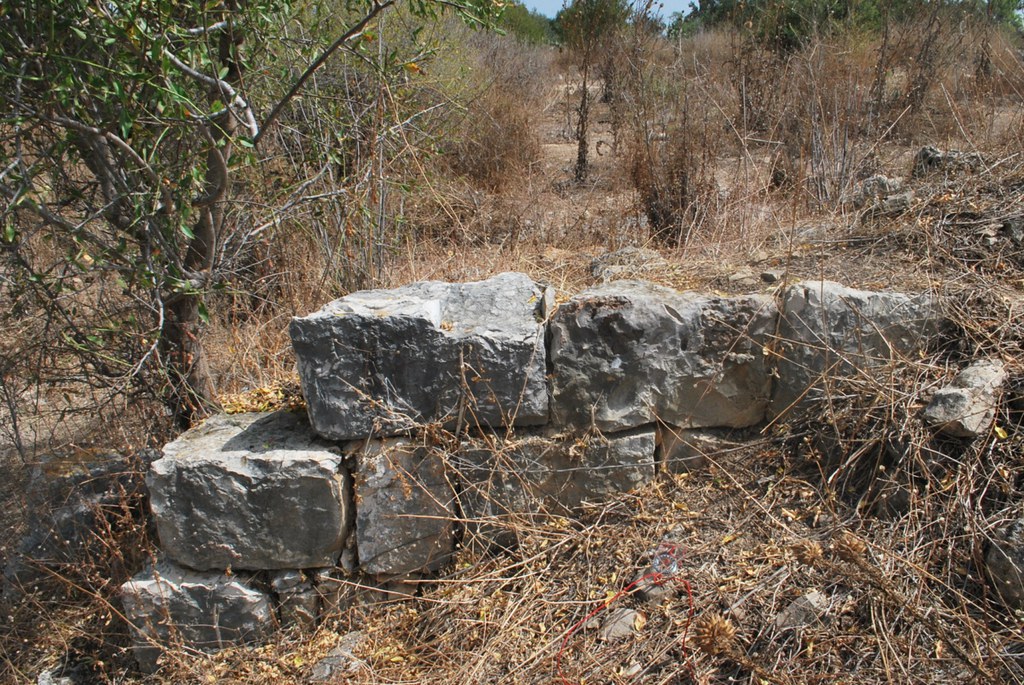
A wall constituting a large structure is probably part of a larger building. There seems to be an exterior wall on the north side that runs 90 degrees east–west. It is composed of large, rough stones. There does not seem to be mortar, but stones are secured by chinking. The other walls consist of cut limestone blocks, except in the northeast corner, where there is an 80 cm wall of ashlar stones and rubble core. The lack of mortar suggests Crusader construction. This wall is wider than other walls on the site, and could possibly be two walls next to each other. There seems to a structure and walls outside the building as well. This complex is located on the highest point of the site.

The other walls form the north, east, and south limits of this structure in an enclosed rectangle. Against the east wall, the highest preserved of the walls, is a collapse of stones set in a curved fashion. This could possibly be a church with an inscribed apse and rooms behind it. Trees growing in the spaces at either end of the eastern wall indicate that they are probably in a space of the rooms located behind the apse (pastophories or baptisteries in a church). There is a thick outer wall, possibly a retaining wall that permeates the space around the building. This probably suggests a complex of buildings.
The presence of plaster indicates that there was a floor. There is also a possible column base in the northwest corner. A mosaic floor within the building was uncovered in the center of the possible Crusader or Byzantine church. A long, thin section remains, which measures 181 cm diagonally and 65 cm at its widest point in the middle, and which is composed of light grey-blue and whitish-yellow tesserae. The tesserae each measure about 2 × 2 × 1 cm. The area of the mosaic is whitish-yellow with some parts of a border exposed. The border is composed of whitish-yellow and light blue-grey tesserae. The border is four tesserae thick and alternating whitish-yellow and light blue-grey in a checkerboard pattern making up two rows. Two solid rows of light blue-grey line the checkerboard pattern on either side. What remains of the design seems to be a border that outlines a rectangular section on the floor. There are two preserved segments of the border at the northern edge that would intersect at a 90 degree angle, making a corner. In some places around the edges, the mosaic bedding composed of plaster is exposed. On the easternmost edge of what remains, the whitish-yellow tesserae seem to be lighter and brighter than the rest. They also have blue-grey speckles on them.

The high presence of late Roman finewares, mainly African Red Slip dating to the fifth and sixth centuries, and some early Islamic wares—but very few middle Islamic or Crusader wares—suggest a Byzantine building that continued into the early Islamic period. Its orientation, prominent orientation, and size suggest a church. The plainness of the mosaic decoration aligns with other local Galilean rural Christian communities (Gal 2002). Another possibility is a wine press installation. The possible combination of multiple churches as well as wine, olive oil, and sugar production on the site suggests a monastic community. Future excavation will work toward testing this hypothesis.
Bibliography
Abu-‘Uqsa, H. 2007. “El-Kabri.” Hadashot Arkheologiyot 119. http://hadashot-esi.org.il/report_detail_eng.aspx?id=526&mag_id=112.
Gal, Z., ed. 2002. Eretz Zafon: Studies in Galilean Archaeology. Jerusalem.
Smithline, H. 2004. “El-Kabri.” Hadashot Arkheologiyot 116. http://hadashot-esi.org.il/report_detail_eng.aspx?id=3&mag_id=108.
Zingboym, O. 2008. “El-Kabri,” Hadashot Arkheologiyot 120. http://hadashot-esi.org.il/report_detail_eng.aspx?id=705&mag_id=114.