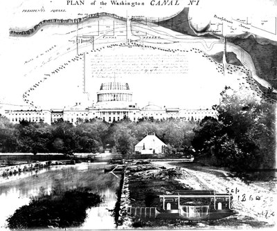
Before the establishment of the District of Columbia, the region at the confluence of the Potomac River and the Eastern Branch was flowing with clean springs, bountiful streams, and ecologically diverse wetlands. A personal recollection from around 1800 recounts the wildlife (ducks, geese, turtle nests, fish stranded in tidal pools) along the former stream corridor that is now Constitution Avenue. The Potomac was so wide it gave the impression of an inland sea as described by invading British during the War of 1812. As Washington and L’Enfant’s vision for the nation’s capital city emerged from the landscape, urban infrastructure (canals, aqueducts, sewers) gradually supplanted in situ water systems. While this infrastructure delivered some positive health benefits in the near-term, it resulted in dire environmental consequences for future generations. This talk explores the 19th century infrastructural transformation of the District of Columbia, and its financial and environmental consequences for the 21st century.
David Wooden is a landscape architect at David Wooden Studio LLC and a former Mellon Fellow in Urban Landscape Studies. Previously he worked at the District Department of Energy & Environment, on environmental regulation and green infrastructure implementation on private and District properties. He was integral in implementing the Green Area Ratio (GAR) regulation, the District’s first landscape requirement. He coauthored GAR interpretive guidance, taught public training sessions and reviewed and approved construction permit submittals.