Introduction
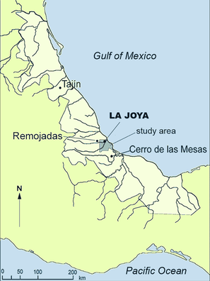
La Joya is a major site built of stamped earth, dating mainly from the first millennium AD. It was the capital of a political entity of the so-called Central Veracruz culture, similar to and contemporaneous with Cerro de las Mesas. It is currently being destroyed by brickmakers, who systematically extract earth from the structure, despite the fact that the site was officially registered since 1935. Its pyramid is part of a layout I have called standard plan, with a ballcourt to the south of the plaza, variants of which become recurrent features of Classic period architecture in Central Veracruz. In the Dumbarton Oaks symposium of 2004, I proposed that this layout reflected the emergence of a state religion related to the ballgame ritual, as part of a strategy of political control by rising elites (Daneels 2008).

In 2004–2007, with funding of the Universidad Nacional Autónoma de México (DGAPA-PAPIIT Project 305503, 2004–2006, US $51,500) and FAMSI (Grant 07021, February 2007–February 2008, US $ 10,000) and the permission of the Instituto Nacional de Antropología e Historia, I have been conducting excavations in what is left of three of the monumental structures (Pyramid, North Platform and East Platform) (Fig. 2). The results so far have exceeded every expectation, showing a complex building sequence, with evidence of refined architecture conforming to Mesoamerican canons, and dedication and termination oblations consisting of sacrificial victims and ceramic vessels and figurines. The two monumental platforms, bordering the east plaza, resulted to be elite residences (palaces), suggesting the inception of state-level organization earlier than expected, at least by 100BC–AD100, shedding new light on Protoclassic (epi-Olmec) and Classic society. The pyramid (and by inference the standard plan layout) seems to be slightly later, with its construction starting in the Early Classic period (AD 100–300), based on ceramic similitude with the second stage of the North Platform. The three buildings have a sequence that spans the first millennium AD.
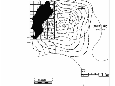
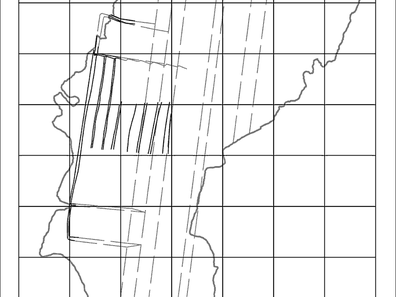
The purpose of the Dumbarton Oaks funding was to focus on the pyramid (as the FAMSI funds went to the monumental platforms). This structure was 26 m high (higher than the Pyramid of the Niches in El Tajín), and had (at least) two building stages, according to ceramic evidence dated between AD 100–300, Early Classic (the first stage, with two successive floor levels) and AD 800–1000, Late Classic (the second and last stage). Brickmaking and mechanical earth removal have severely deteriorated the last building stage, as well as a large part of the first building stage. Yet in a three month field season in 2005, it was possible with 112 m2 trenching to identify the remnants of the west façade of the substructure, with evidence remaining of the lower three tiers and the central 6 m wide staircase with lateral ramps. The initial reconstruction suggested this was a nine tiered pyramid with probably four staircases (one on each side). Now, the completed excavations show a more sophisticated architectural design.
Objectives
The objectives were to excavate (1) what is left of the last structure, to understand the system of fills and thus expose the substructure's facade, (2) the foundations of the first and last building stage, which were expected to be extant under a layer of overburden on the eastern half of the structure, and (3) the centre of the Pyramid, at the antique surface level, as that would be the usual place of the main dedicatory offering. These objectives were attained, and the results are given forthwith.
During excavations, we hoped to obtain charcoal samples from good contexts to establish independent absolute dates for the structure's sequence. A small series of samples was obtained from paleosoil below the structure, as well as from possible organic dedication offerings at the centre of the substructure, and from the fills of the late structure. The samples will be processed at the now certified Laboratory for Dating of the Institute for Anthropological Research at UNAM.
Field season and strategies
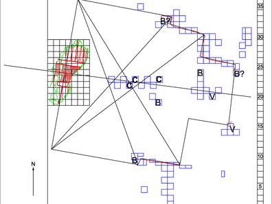
The fieldwork was carried out as programmed, during the dry season, from November 2007 to May 2008, a 27 week season (instead of the programmed 13 week, as the budget for workmen was concentrated in fieldworkers, forgoing the cook and the sherdwasher). The complete site excavation report, including chronometric dating, and material analysis, structural, paleobotanical, and chemical analysis will take longer due to the amount of samples recovered and to laboratory schedules. These complete data and interpretation will be part of the final La Joya publication by UNAM.
The methods consisted of extensive excavations of the western façade, and test pit excavations in the eastern sector to define the building's foundation limits and form, as well as central trenching to define its sequence and possible central offering. Walls, floors and fills exposed were sampled for architectural technique (composition, resistance, pigments), and chemical and botanical residues; finds like burials and caches were extensively sampled for charcoal, and chemical and botanical residues.
The digs consisted in three approach trenches (using the alternate square system), to locate the north, east and south façade, and their stratigraphic sequence. A fourth trench explored what was the centre of the building at the time of construction. Of the 80 stratigraphic test pits excavated, 24 reached the sterile stratum, to define the contour of the original surface level (paleosoil) at the time of occupation; another 56 testpits were then dug till the original floor level, to define the contour of the Early Classic period substructure.
It was found that the foundation of the second and last, Late Classic period structure had been obliterated by the brickworkers labour in foregoing years.
Results
1. Building techniques
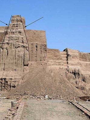
The final stage of the pyramid, as registered in 1999, was a structure still 22 m high, with slopes at an angle of 32º, higher and steeper than the Preclassic period pyramids (Daneels 2002: 197). This indicated that some sort of strategy was applied to control the internal pressures of the earthen fill.
The excavations show that the solution to this problem was alternating fill blocks (approximately 1 m high and more than 6 m on the side) of clays and sandy loams. Both types of soils were readily available in the surroundings of the site. The clay blocks (made of gley soil obtained from deepening the artificial water reservoirs surrounding the monumental core of the site), due to their cohesiveness, would form buttresses containing the blocks of sandy loam. Inversely, the sandy loam blocks (whose material was obtained from the alluvial soils all around the site) would achieve a better compaction, therefore a more stable surface, than clay which tends to crack in dry conditions and expand in wet. Thus, alternating the fill blocks allowed to take advantage of the quality of each soil class and compensate for their weakness.
To facilitate carrying up the fill from the plaza level, the staircase of the substructure was kept accessible by building containing walls with sloping sides on top of each of the staircase ramps, against which the fill blocks abutted.
These containing walls, made of clayey loam, would be raised every time a fill block layer was completed. The filling up of the staircase gap was thus the final stage in the building process, and it was done using mostly loam, probably as base for modelling the final stage staircase. In this situation, the internal pressure generated by the amorphous clayey loam fill would be easily contained by the retaining walls and by the mass of the pyramid built of alternating fill blocks.
These findings are absolutely novel, as no information existed before on the techniques of earthen architecture for Classic Central Veracruz. I first inferred that the inspiration for this building method had its origin in the monumental platforms, as their sequence indicated that in order to raise the main platform level the existing buildings, or rather, their supporting structures (in form and size quite similar to the pyramid's fill blocks), were kept intact and the intervening spaces filled up. Yet extensive excavations of a sector of the first, Late Preclassic, building stage of the North Platform indicate that this technique was already established.
Exploration of the substructure fill system of the pyramid itself does not show the use of the same technique. The fill of the basal platform is pure sand (probably obtained from the paleodune), contained in its perimeter by clayey loam strata, while the upper tiers of the pyramid consist of a superposition of dark brown loamy fills (varying from clayey loam to loamy clay), whose height corresponds to the elevation of the successive tiers. The large quantity of sherds (including Early, Middle and Late Preclassic types, along with the Early Classic types contemporary with the building) and occasional bone and shell fragments suggest the fills were borrowed from the surface alluvial soils, erasing evidence of early, apparently domestic, occupation. As I am still in the process of vectorizing the drawings of profiles and cuts, no sketches of the building system are as yet available.
2. Reconstruction of the original structure size and aspect
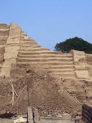
The pyramid was raised on the highest point of the paleodune, as the sterile soil was found at its highest elevation in the trench dug at the original centre of the structure. It was possible to define the contour of the substructure: it was a T-shaped building with a main body surface of 43 deep x 50.5 m wide. The east façade was 4.6 m narrower than the other facades, with a projecting rectangular platform that we interpret as the base of the main staircase, 20 m wide, with lateral ramps, and starting 13 m to the east of the structure base (Fig. 5). The T-shaped layout seems to be part of the original plan, as the fill of the lower tier (including the projecting staircase platform) consists of a homogeneous sand fill, contained by a clayey loam stratum buttressing it all around. The ceramics in the sand fill are very scarce, but more sherds were recovered from the surrounding containing stratum, consisting mostly of Formative period types, though a small but significant percentage indicated that the fills were of Early Classic date (approx. AD 100–300, based on ceramic typology, as radiocarbon dates are pending).
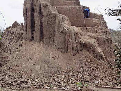
The prepared surface from which the structure arose was quite level (mostly between -9.19 to -9.28 m below datum), with the plaza floor showing a quite pronounced drop of 9º, after that running almost horizontally above the paleosoil to the west and south of the pyramid (at approximately -10.00 m below datum). At that first moment of construction, there is at least evidence of two staircases: one to the west, actually conserved, and one to the east, if we are correct in interpreting the projecting platform as the stair's foundation. The latter faced the main plaza surrounded by the monumental platforms, now identified as palaces of the political and the religious leaders, respectively the North and the East Platform (Daneels 2008) (Fig. 2).
The plaza floor was raised considerably some time later in the Early Classic period, to a level at -8.36 m below datum. This seems to have been the main plaza floor for the rest of the site's history, on which the south plaza structures were built, and later, the final, Late Classic, pyramid was erected. Unfortunately, its exposure to the elements and later use as a working level for the brickworkers completely eroded the plaza flooring, reason for which we were unable to locate the contour of the last building stage: the undisturbed layer of the pyramid at present is found at -8.40 m below datum on average. The contour of the later building can thus only be inferred from the topographical sketch of 1937 (Escalona Ramos 1937) and the topographical survey our project realized in 1988.
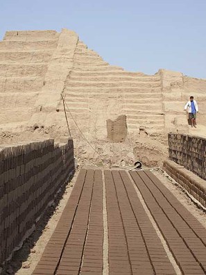
After the plaza floor level was increased, still in the Early Classic period, we infer that the south plaza was erected, with the ball court to the south. At that moment, it is probable that a new staircase was adjoined to the south, fronting the court, as is the case in the standard plan layouts of other Central Veracruz sites built out of stone (Daneels 2008). As there is no antecedent of Mesoamerican pyramids with three staircases, we reconstruct this phase of the pyramid as a four-staircase building, one on each façade. The west staircase was still functional (as proven by the excavations), the east staircase must have remained so as well, as the monumental platforms continue to grow and remain joined with the pyramid by common plaza floors. The north staircase is completely hypothetical, but would conform to common Mesoamerican building canons. Four staircase pyramids occur throughout Mesoamerica, though they are more common in the Maya area, where they are found from the Formative (Uaxactún), through the Classic period (Chichen Itzá) and the Postclassic (Mayapán), just to mention the best known examples.
The excavations revealed that in the conserved part of the west façade there were six tiers, instead of the five inferred through the preliminary reconstruction (Figs. 7–9). This results from the fact that the higher the tier, the smaller it was built.
| Tier | Height | Width |
|---|---|---|
| 1 | 120 | 120 |
| 2 | 115 | 115 |
| 3 | 120 | 100 |
| 4 | 90 | 100 |
| 5 | 90 | 70 |
| 6 | 93 | incomplete (40) |
This does not seem to be random, but probably corresponds to a desired optical effect of making the pyramid appear larger and higher than it actually is. Such optical corrections are frequently reported from the old world, being commonly applied in antique Greek and Roman architecture. In Mesoamerica, though, such application of a thorough acquaintance of the laws of perspective has to my knowledge not yet been reported. At this point of analysis, I am as yet unable to propose a reconstruction of the substructure. It is obvious I will need the help of an architect to resolve the problem, due to the T-shaped ground-plan and the exponential size of the tiers. Yet it is clear that the pyramid had more than the originally inferred nine tiers.
Thus, the data acquired are a clear proof that earthen architecture on the Gulf coast of Mexico was a full-fledged art, up to the most exacting Mesoamerican canons. This reverts our previous preconception that the mounds were amorphous heaps of earth crowned with thatched huts.
3. Dedication offerings
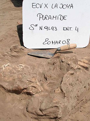
The excavations revealed the existence of both corner offerings (as are common in the North Platform) and axis offerings (predominant in the East Platform), showing that the Pyramid reunites both symbolic ways of placing oblations (Fig. 5). The type of offerings is also similar: (sacrificed?) human bodies, ceramic vessels and figurines. Yet the quantity and quality of the offered items is much poorer than those located in the monumental platforms.
The earliest deposit was found at the centre of the pyramid, apparently deposited on top of the paleosoil immediately before the start of construction. The excavations failed to reveal the expected lavish cache. Yet, some sort of ceremonial seems to have taken place involving the burning of organic material, as large patches of carbonized organic matter were located immediately on top of the paleosoil, below the sand fill of the basal structure (Fig. 5, squares S'''23 and T'''22). The absence of such concentrations in the other deep pits suggests that these are part of an activity in the center of the building, right before the start of construction. Analysis of carbonized samples for radiocarbon dating, and of botanical and chemical residues are pending.
The other deposits associated to the substructure's construction are within the sand fill of the basal platform. Two are placed on the corners of the main pyramid body, where the T-shaped narrowing of the east façade starts (Fig. 5). To the south, a partially destroyed interment consisted of two adult male, lying supine, oriented to the north (the individual to the west had his head covered by a vessel).
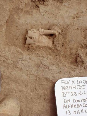
A possible symmetrical deposition was located on the north corner, but as it came up the day before last of the field season, it was covered up and reserved for later study by a physical anthropologist. Both of these corner deposits were within the sand fill of the basal tier of the substructure, well above the paleosoil.
Other deposits were found in a roughly symmetrical pattern along the central east-west axis. There are two deposits of human bones (a pelvis bone and legs in O'''19, and a skull covered by a bowl in H'''24), a complete vessel buried upside down in F'''20, and lenticular patches of carboniferous earth in O'''19 and 23. These deposits are more problematical, as they may be part of a ceremonial or may simply be part of the fill. Residue analyses are pending.
At the corners of the projecting platform to the east, two deposits were found on top of the last (upper) floor level, thus belonging to the period of use of the substructure. Two concentrations of possible bone remains, completely eroded, were found at the foot of the north ramp, while a complete vessel associated with burnt organic matter was located outside the south ramp. The fragmentary nature of the organic remains makes a definite interpretation of the deposits impossible at the moment; the residues will be analysed in the UNAM laboratories.
Belonging to the second and last, Late Classic building stage, several axis offerings were found consisting of 5 almost complete examples of "Dios Narigudos" figurines (found by the hundreds in the East Platform, often also in intentionally incomplete form). These were found in the west facade, set in the fill of the staircase.
Conclusion
Earthen architecture has been neglected in Mesoamerican studies, and the sites of lowland Veracruz and western Tabasco, where they are the norm, are being destroyed by modern infrastructure projects. The results achieved by the La Joya Pyramid excavations show the quality and complexity of this architecture. The T-shaped ground plan, the use of perspective to create an optical illusion of grandeur, the ingenuity of the earth fill strategies, the presence of axial and corner offerings including human (sacrificial ?) interments, all are novel data and place this architectural tradition squarely amongst the most refined Mesoamerican architectural arts. Therefore, beyond the academic contribution to the understanding of Classic period Central Veracruz socio-political organization, which will become a book published by our institution, I am sure that the now exposed pyramid, as a monument and as an icon, will achieve a better appreciation of Gulf lowland earthen architecture, and create public and official awareness and thus obtain a more effective protection for sites that are still complete. I am grateful to Dumbarton Oaks for the grant which made this possible. In the case of La Joya, I hope eventually to be able to interest the authorities in creating a site museum, as a lasting testimony of the capital it once was.
Bibliography
2002
El patrón de asentamiento del periodo Clásico en la cuenca baja del río Cotaxtla, Centro de Veracruz. Un estudio de caso de desarrollo de sociedades complejas en tierras bajas tropicales. Doctorado en Antropología, División de Posgrado de la Facultad de Filosofía y Letras e Instituto de Investigaciones Antropológicas, Universidad Nacional Autónoma de México.
2008
Monumental Earthen Architecture at La Joya, Veracruz, Mexico.
2008
Ballcourts and Politics in the Lower Cotaxtla Valley: A Model to Understand Classic Central Veracruz? In Classic-Period Cultural Currents in Southern and Central Veracruz, edited by Philip J. Arnold III and Christopher A. Pool: 197–223. Dumbarton Oaks Research Library and Collections. Harvard University Press, Washington D.C.