In the past the study of Islamic gardens was based for the most part on historic texts and images, not on actual remains of gardens. The number of preserved gardens is small, and even fewer have survived in their original state. Only fairly recently, archaeological projects—for example in al-Rummaniya (Córdoba) and in the Generalífe (Granada) in Spain—have begun to add to our knowledge of Islamic gardens. The study of Islamic gardens poses particular problems to archaeology, not only because of the difficulty of detecting plants but because of the great size of the gardens, which would make large-scale excavations necessary. The objective of the present project was to study an Islamic garden at Córdoba with the help of a geomagnetic survey, a geophysical method that has proven useful in Egypt to get an idea of the layout of large-scale gardens.

In the 10th century, Córdoba was famous for its extensive gardens. By far the largest of these was the garden of the caliph at Madinat al-Zahra, a palatial city founded in 936 and inhabited until at least 1010. Historic texts mention repeatedly that the main palace area of the city overlooked a large garden (riyad or rawd). The remains of the garden can be detected fairly easily on aerial images. With a total surface area of some 32 hectares (80 acres), it was larger than the contemporaneous garden of the Fatimid caliph at Cairo, and almost as large as the slightly earlier gardens of the Abbasids at Samarra (Iraq). Only a fraction of the caliphal garden has been excavated to date: the Jardín Alto and the neighboring Jardín Bajo, with a total area of four hectares (10 acres).
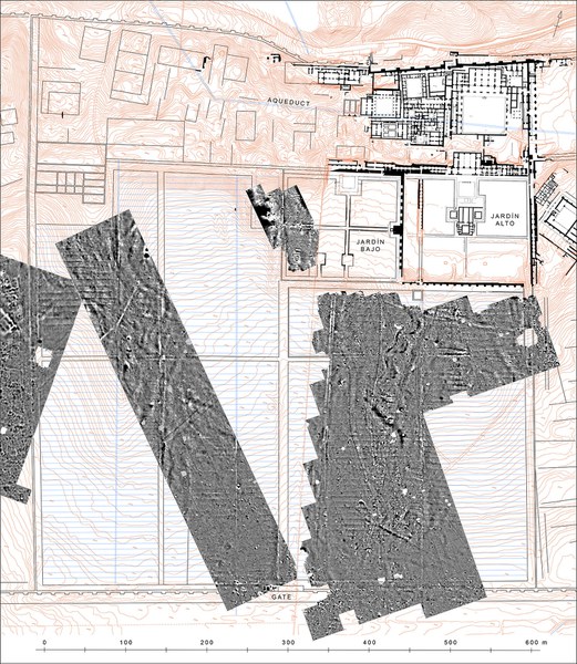
Over the course of four weeks, Tomasz Herbich of the Polish Academy of Science surveyed a large part of the unexplored area of the garden (10 of the 32 ha). The survey was carried out using Geoscan Research FM 256 fluxgate gradiometers measuring the vertical component of the magnetic field. Measurements were taken in zigzag mode in a grid of 0.50 m by 0.25 m. The results were presented as a grey-tone magnetic map in positive scale (the highest values correspond to black, the lowest to white). The results of the survey are better than hoped for, and furnish for the first time a detailed image of the entire garden area of Madinat al-Zahra. Walls, walkways, and channels are visible on the geomagnetic image as light anomalies. In addition, a regular pattern of dark anomalies is visible, which implies trenches were dug into the ground. They provide the most conclusive evidence for the layout and character of the garden.

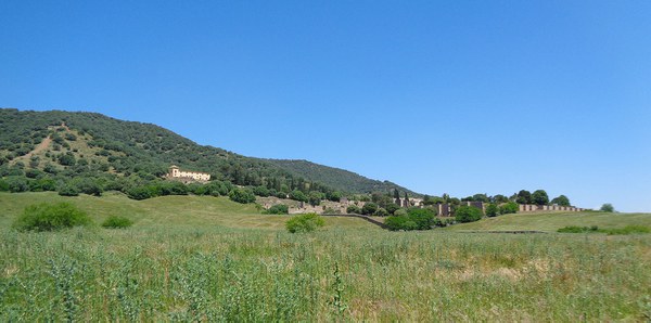
Contrary to previous hypotheses, the geomagnetic survey clearly shows the entire garden area was planned as a single huge garden with an overarching design. The 520 × 620 m garden was surrounded by 8–10 m wide pathways. Two additional pathways divided the garden into four parts, like a Persian chahar bagh. At the southern end of the central axis the remains of a large gate are visible, possibly the “garden gate” mentioned in historic sources. A similar gate was located at the western end of the transversal axis. This may have served as the main access to the palace for the inhabitants of the western sector of Madinat al-Zahra—possibly the palace guard. On aerial images the remains of a large palace are clearly visible at the northwestern corner of the garden. The palace was on a hill and had a spectacular view across the entire garden.
The geomagnetic image reveals details about the structure of the irrigation system. Three main water channels run from north to south, following the slope of the topography. Near the northern end of the central channel lies a large water reservoir. A secondary basin of smaller size is preserved at the northern end of the eastern channel. For topographic reasons the western channel starts at a much higher altitude than the others and may have been connected directly to the aqueduct of the city, farther uphill.
A regular sequence of parallel lines is visible on the geomagnetic image across the entire garden area, crossing the ground from east to west. Up to 67 such lines are visible, at an average distance of 7.5 m. The lines point to the existence of earth channels that distributed the water across the garden surface. In some areas even smaller channels can be recognized running north to south, which brought the water to individual plants. The geomagnetic survey does not provide information on what kind of plants were grown. A distance of 7.5 m would be suitable, for example, for fruit trees. The survey does show, however, that the system of irrigation was the same throughout the garden.
The only part of the garden with a different layout is the northeastern zone, where the Jardín Alto and the Jardín Bajo are. The two gardens are each about 150 m wide and 135 m deep, and are internally divided into four parts by two crossing walkways. The geomagnetic survey revealed the western limit of the Jardín Bajo, which has not been excavated. The enclosure wall and walkways of stonemasonry are visible. A rectangular structure in the southwestern corner of the garden might be a cistern. On the surface a fine grid of lines can be detected, possibly deriving from the plantation of the garden. The inclination of the surface is much less than the rest of the garden and a different irrigation system must have been applied here. Water channels surround the gardens on all sides, so it could probably be flooded.
The survey at Madinat al-Zahra has proven the usefulness of geomagnetic surveys for the study of large gardens. To verify the results of the survey, and to gain information on the kinds of plants that were planted here, limited archaeological excavations will be needed in the future.