The two best-attested systems of processional pathways in the Pre-Columbian Americas belonged to the Incas and to the Mayas. The Maya system was composed of white roads (sacbeob) in the Yucatan, while the Inca system was formed by lines of sacred shrines (ceques) in the Andes around Cusco. These pathways can help shed light on both cultures’ processions.
Sacbeob
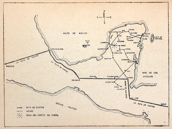
Many Maya sites were linked by roads called sacbeob, or sacbe in the singular. The term sacbe, usually translated literally by modern scholars as “white road,” comes from Yucatec Maya today, but classic Maya had similar terms. Sacbeob were raised roadways that consisted of stone retaining walls with fill between them, paved on top with a powdered limestone or white plaster surface. The Maya constructed them on a large scale from about 300 BCE to about 1100 CE, although they remained in use at least until the conquest.
Sacbeob were used for transportation but probably also performed important symbolic functions. Modern scholars have proposed, for instance, that sacbeob could show off political power and mark boundaries, or possessed astronomical and ritual significance. Early postconquest writers commented that local people made “pilgrimages” along the roads, comparing indigenous practice to Christian customs. Scholars also think that sacbeob served as sites for procession in the Classic Maya period.
Ceque System
The Inca, like the Maya, constructed an impressive road system. Some of these were used for formal ritual movement, but processions could also take place away from the roads, more directly connecting significant places in the environment.
The Incas viewed their landscape as charged with sacred energy. Throughout the Andes, they believed that unusual features of the environment, including large stones, mountain ridges, and streams, were loci of particular power, and they honored them at shrines known as huacas. The most prominent huacas around Cusco were arranged into conceptual lines known as ceques, which radiated out from the Qorikancha, a temple at the center of the city.
Each ceque, of which there were 41 or 42, was composed of a certain number of huacas, and ran from Cusco through the surrounding landscape. There were at least 328 huacas included in the ceque lines around Cusco. Some seem to have marked spatial boundaries, some the sites of historical events, and others seem to have had astronomical or calendrical significance. Worshipers processed along each ceque to honor the huacas of which it was composed.
References
- Brian S. Bauer, The Sacred Landscape of the Inca: The Cusco Ceque System (Austin: University of Texas Press, 1998).
- Antonio Bustillos Carrillo, El sacbé de los mayas (Mexico City: Costa-Amic, 1964).
- Cristóbal de Molina, Account of the Fables and Rites of the Incas, ed. and trans. Brian S. Bauer, Vania Smith-Oka, and Gabriel E. Cantarutti, 1st ed, William and Bettye Nowlin Series in Art, History, and Culture of the Western Hemisphere (Austin: University of Texas Press, 2011).
- Justine M. Shaw, White Roads of the Yucatán: Changing Social Landscapes of the Yucatec Maya (Tucson: University of Arizona Press, 2008).
- R. Tom Zuidema, The Ceque System of Cuzco: The Social Organization of the Capital of the Inca, trans. Eva M. Hooykaas, International Archives of Ethnography, Bd. 50, suppl (Leiden: E. J. Brill, 1964).


